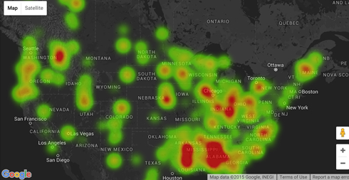
The truckload forecast is a simple visual map of where freight is moving around the country. The layout of the page is similar to a weather map or heat map of the United States with the hot spots or red colors freight density. The denser the area for freight the more per mile you can get out of that locations.
How use the Freight Forecast Map to check the reality of this amazing free freight tool. Pull up the Truckload Forecast page. It is listed under the Truckload Board menu. Select your equipment and select the dates. Then identify the areas to look and go use the free load board and search freight by Map Search, State, Zip / City or the Mobile load Board.